
Highdyke Junction to Bridge End, Colsterworth (via B6403)
modern photographs and description by John Pegg and C. Taylor
edited by John Clayson
Introduction
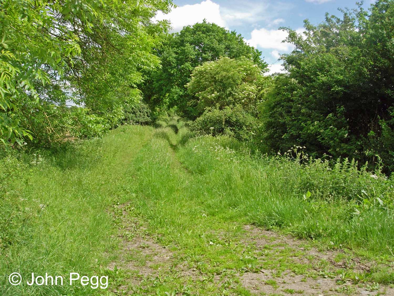
This series of photographs was taken by John in the summer of 2017 while walking the northern section of the former High Dyke branch line, a distance of 3 miles.
The branch was a mineral line which transported locally mined ironstone to Highdyke sidings on the East Coast Main Line, just north of Stoke Tunnel. From there it was taken to iron and steel works in Lincolnshire and the North Midlands.
There had been a junction at Highdyke since 1882 when a third running line from Grantham, the 'Up Goods', was extended as far as the approach to the two-track Stoke Tunnel. The High Dyke Branch had originally been promoted in about 1912 as the Waltham and Highdyke Railway, because it was intended to connect Highdyke with Waltham-on-the-Wolds, the terminus of a Great Northern Railway branch line from Scalford, Leicestershire.
The branch was declared open by the Great Northern Railway Company on 3rd March 1919. However, the connections from the main lines had been installed at Highdyke by November 1916, so the branch may well have been in partial use well before its official opening.
The High Dyke branch was built relatively cheaply across undulating countryside and it was quite steeply graded in parts, being known to generations of Grantham train crew as 'the alps'. To avoid runaways on the sharp descent approaching the junction at Highdyke, regulations limited the number of loaded wagons that could be brought down the branch. Longer trains were assembled in the sidings for onward transport over the main line.
The ironstone mines were mainly opencast and they had their own private railway systems. There were loading points and exchange sidings at several locations on the branch. No regular passenger services were ever operated, but there were at least two special excursions, on 19th June 1960 and 15th April 1972. The branch closed in August 1973 after ironstone mining ceased. There was an attempt at a preservation and leisure railway initiative - see here - but it failed, and by autumn 1975 all the track on the branch had been removed.
As a comparative latecomer to the local transport infrastructure the High Dyke Branch intersected many existing landscape features, both natural and man-made. The Great North Road (A1) was spanned by two bridges, the earlier dating from the line's construction and the second, to the east, a result of the realignment and dualling of the A1 in 1959-61. The River Witham was crossed and several roads, lanes and footpaths were intersected, requiring bridges or gates. John has captured evidence of most of these crossings in the photographs.
The maps show the area in around 1974 (after the branch was closed but before the track was removed), unless otherwise noted.
Editor's note: Highdyke or High Dyke?
Apparently both.
Since about 1919 the locality where the branch joined the East Coast Main Line appears to have been referred to in official railway documents as 'Highdyke' (one word) or 'Highdyke Junction'. Certainly in the mid-20th century the official name of the signal box, as printed on the box diagram, was HIGHDYKE, and this is also its name on the British Railways era Telephone Circuit Card illustrated further down this page.
However, Great Northern Railway paperwork of the 1880s uses 'High Dyke' and the joiner who, presumably following instructions, fixed the letters to the signal box nameboards in the same decade also left a space: HIGH DYKE.
The line itself is correctly referred to as the High Dyke Branch because High Dyke (two words) is the name of the B6403 road which, for its first 3 miles, the line closely paralleled.
To add to the variety of spellings available, the Ordnance Survey tends to have used 'Highdike' and 'High Dike' on its maps!
Other/alternative insights are very welcome - please leave a comment.
Highdyke Yard


One of Grantham shed's class O2 heavy freight locomotives has just brought 15 wagons filled with ironstone down the branch. The brake van has been uncoupled and the loaded wagons will be drawn past the camera and propelled into sidings, mainly hidden by the locomotive, to join others ready to be taken to the steelworks.
On the left, behind WD Austerity class locomotive No. 90169 in one of the sidings, is the entrance to Stoke Tunnel. The Virgin Trains East Coast expresses will be along in a little over 50 years!
Photograph by Humphrey Platts

Photograph taken by Humphrey Platts

Photograph by Humphrey Platts
Humphrey Platts' visit to Highdyke on Thursday 5th September 1963, when the photographs above were taken, was arranged by his friend Walter Dale who was Yard Inspector at Highdyke. Walter was an Alderman of the Borough of Grantham and he had been Grantham's Mayor in 1949-50. This was the final week that Grantham-based locomotives worked the branch, because the shed closed the following Sunday.
John Pegg worked at Highdyke signal box and there are some of his recollections here (scroll about ⅓ down the page).
Let's take a final look at Highdyke with a wonderful panoramic view taken by Tom Boustead in February 1974.

At this time there was no regular traffic on the High Dyke branch because ironstone mining had ceased in summer 1973. However, the infrastructure remained intact until October 1974 to provide access to the Market Overton site of Flying Scotsman Enterprises.
With the tracks clear of traffic this is a good opportunity to study the layout. In front of the signal box are four of the six sidings used for marshalling groups of outgoing full wagons into complete trains, ready to depart northbound on the main line. On their left, beginning to rise at a gradient of 1 in 40 on an embankment, is the High Dyke branch to Stainby and Sproxton. Rising beyond the box are two sidings where empty wagons arrived before being taken up the branch. The connection into the main line is behind the box, leading out to join the Down Main as it curves away to the right. The line descends at 1 in 200 from Stoke signal box, through the tunnel, past Highdyke and all the way to Grantham, 4 miles further north.
Deltic No. 55001 St. Paddy climbs towards the tunnel with the 08:00 from Edinbugh Waverley to London King's Cross. This happens to be the date when this locomotive was officially renumbered from [D]9001.
Photograph taken by Tom Boustead.

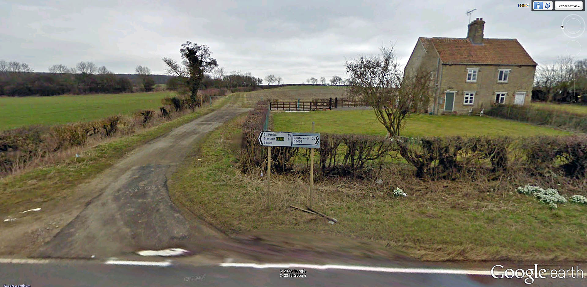
The route is virtually impassable due to large trees, thorn bushes, brambles and nettles. So for now we'll travel south - on foot or by bike or car - along the B6403 High Dyke (known to the Romans as Ermine Street) with the branch on our left. We will turn off where we can to rediscover the railway.
Bridge No.1
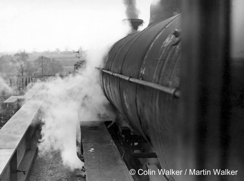
Our first call is at Bridge number 1, which still carries a track to Highdyke Farm over the cutting.


A train of empty wagons from Highdyke approaches bridge number 1 in July 1963. Click on the image to visit the owner's website.

Photograph taken by Colin Walker

The fixed (i.e permanently at caution) distant signal of High Dyke signal box stands on the skyline.
Photograph taken by Colin Walker
Park Farm Lane Crossing
About ¾ mile south of Bridge number 1, Park Farm Lane joins the B6403 from the left. There was a gated but unstaffed level crossing about 150 yards along the lane. Road users opened the gates when required, taking responsibility to ensure that it was safe to cross the line. Locomotive drivers were required to give a warning whistle as they approached.

While here we may pause to remember a fatal accident at Park Farm Lane Crossing in late January 1941. In very thick fog Blanche Arthur of Swayfield was helping her husband Horace, a baker, with his delivery round. Blanche was opening the crossing gates ahead of the baker's van driven by Horace when a locomotive propelling a brake van suddenly appeared out of the fog, travelling from the left as we view it here, and knocked her down. She may not have heard the train approach because of the muffling effect of the fog and the noise of the van's engine.

Canner's Lane Crossing
The next lane on the left, Canner's Lane, also had a gated level crossing about 150 yards along the lane from the B6403.
Burton Lane Crossing
We are just over 1½ miles south of Highdyke at Burton Lane, the site of a level crossing where there was a gate keeper's cabin and sidings.


This is our first encounter, somewhat surprisingly, with the legacy of ironstone mining activity. The extensive industrial premises north of Burton Lane here are on a former 'brownfield site' which was first developed by the United Steel Company in 1958-60 as Easton Mines. It was an attempt to exploit some deeper ironstone deposits by mining, rather than by openncast quarrying. The venture proved to be uneconomic and Easton Mines closed in 1967.
In 1970 the site was taken over by Christian Salvesen who, by 1979, had established there what was then claimed to be 'the largest frozen food centre in Europe'. In 1982 McCain's (the Canadian potato chip / french fry manufacturer) began manufacturing on the site which, inevitably, became known locally as 'the chip factory'.
For further information see: The Ironstone Quarries of the Midlands - History, Operation and Railways: Part VIII South Lincolnshire by Eric Tonks, especially pages 125-129 (Easton Mines).


Photograph by David Ford

From the collection of R. Pike

Photograph by John Ford
Ridd's Farm Crossing
Another farm lane leads in from the left with a former level crossing about 100 yards in.


Crossing the Great North Road

Here, 350 yards of the old branch line's formation have been wiped off the map to allow the B6403 to cross above the dual carriageway A1. But don't worry - once we pick up the line on the other side there'll be a proper footpath to help us on our way.

A is where the trackbed temporarily ends;
B is the site of a concrete and steel bridge - bridge number 1A - built in 1959-1961 when the dual carriageway Grantham bypass was constructed;
C is the site of a brickwork and steel bridge - bridge number 2 - built in 1917 across the 'original' Great North Road. The west abutment survives, as we'll see.


Now let's hop up onto that bridge and into our time machine...
Photograph taken by Colin Walker


Photograph taken by Colin Walker

Photograph by John Ford.

Photograph courtesy of Colsterworth & District Parish Council

Photograph courtesy of Colsterworth & District Parish Council
From here onward Colsterworth & District Parish Council has laid out a Nature Trail along the old branch line. We'll explore this in Part 2!
Continued in Part 2: Bridge End, Colsterworth to Stainby Station
Back to Railways Rediscovered
Well researched article, thank you.
Superb article. Looking forwards to part 2.
Paul A.
Thanks Paul - hopefully Part 2 will be ready by the summer.
I had the dubious honour of driving over the old bridge across the A1 in a 17-tonne lorry when they were drilling exploratory bore holes for the new junction. After dropping off some 1-tonne bags of pea gravel on the eastern side of the A1 I asked the guy where I could turn round, and he said "Go over the bridge. It's safe enough, trains carrying hundreds of tonnes of iron ore used to use it." Halfway across it dawned on me that it was years since it had been used! I was quite glad to reach the Colsterworth side without any problems.
Hello Del,
Thanks for telling us about your trip over the bridge in a lorry. Perhaps it was fortunate that you'd already dropped off the pea gravel and didn't cross the bridge so fully loaded!
John Clayson
Interesting article and pictures.
I can remember as a schoolboy on summer holidays in Colsterworth, Brush Type 2s and Type 4s in 1971-73 regularly using the line. The line was always busy, serving Colsterworth, Buckminster, Market Overton and Sproxton Quarries.
I was surprised when preserved steam trains started appearing in 1974. Quite a sight after the dirty ironstone wagons!
A fascinating read and some revelations for me about the old line and its route. Thank you!
Hello Chris,
We're very pleased to hear that you enjoyed the first part of our journey along the High Dyke Branch. There will be more to follow.
Best wishes, John Clayson
I moved to Colsterworth about 10 years ago and now often walk our dog along the High Dyke track bed. I also used to travel through here on the A1 from about 1968 onwards and now wish I had stopped off to take pictures of the railway.
Unfortunately, I didn't and so this article is very much appreciated.
Looking forward to part 2.
Best wishes,
Chris Walsh
Thank you Chris. Part 2 is nearly ready - we hope to publish it in a few days' time.
Best wishes,
John Clayson
A fascinating and very informative read with some "period" photos to help with the exact locations of the more "modern" shots. Oh for a time machine !! Regards Peter Davis
Hello Peter,
Many thanks, we're pleased to hear that you found this page such a worthwhile read. We've recently discovered a short account of the High Dyke Branch during its working life. It's here and you will need to scroll down to the third chapter.
Best wishes,
John Clayson
The photographs from September 5th 1963 were taken on my 3rd birthday. At that time my dad Gerry worked at High Dyke Station Box and we lived in the Railway's 2 up, 2 down High Dyke Cottages next to the bridge. We moved to Great Ponton about 65/66 and dad's job moved him to Grantham Station.
Hello John. Thank you for getting in touch. I can't imagine what it would have been like to live in the cottages at High Dyke with the sound of railway activity all day and all night, though I expect as a 3-year-old you would sleep through almost anything when sufficiently tired.
John Clayson
Stewart Short
My grandad lived in the corner house on the south side at High Dyke. I believe he was foreman on that section of the track. He was involved when they lowered the track through Stoke Tunnel and also the new bridge at Colsterworth - I remember going there one evening when they were working on it under floodlights.
As I child I stayed with my grandparents, trainspotting at Stoke Tunnel and watching the iron ore trains. I also remember going into the signal box. All a long time ago.
Thank you for posting this interesting comment Stewart. In case you haven't seen them there are some short clips of colour film made at High Dyke here.
John Clayson
I lived in Louth 1956 - 58 and our house was next to the East Lincs line. I well remember the iron ore trains as our house used to shake when they went past.
Did the marshalled ore trains at High Dyke run to Scunthorpe and if so what route would they take? Were the trains I saw at Louth from the Northants mines maybe?
Hello Chris. Many thanks for your query. A loaded ironstone train weighed around 1,000 tons, so it's not surprising that they shook a few buildings by the lineside. There's a great description of the ironstone train workings from Highdyke to Frodingham and other destinations on another page of our website here, contributed by Grantham fireman Roy Vinter, which I think will answer your question about the route. I don't know whether ironstone from Northamptonshire was regularly hauled to Scunthorpe and, if it was, which route it took.
Best wishes,
John Clayson
Yes, there were iron ore trains from Northamptonshire, but I don't have immediate access to my WTTs - so I can't be sure of the frequencies.
The wagons were marshalled near Welham Junction and the trains ran via the GN&LNW to Frodingham via Bottesford South and East Junctions. I only lived near the Sleaford - Boston line in the 1960s and saw a few 8Fs on the trains, but they may have run while I was at school for much of the time, or possibly changed engines at Bottesford.
I have read a report that a LNWR 0-8-0 managed to reach as far as Boston, but had to be taken off as the crew didn't know the road beyond there. How true this is, I don't know.
Thanks Jon,
The GN&LNW route could have been fairly busy with ironstone/iron ore traffic because as well as the through trains from Northants there were a number of sidings along the way which were loading points for nearby quarries.
John Clayson
I have now looked at my 1961 WTT and there were two trains in that year, and neither came from Welham Sidings as I intimated.
There was a 12:45 Blisworth to Frodingham which passed Barkston East at 17:30, but that only ran on Mondays and Tuesdays; plus a 15:45 Market Harborough (not technically Northamptonshire I know, but probably conveyed wagons from the area) to Normanby Park which passed Barkston East at 19:22.
The empties returned on the 0726 Frodingham to Blisworth, passing Barkston East at 1306; but I can't find a return working for the Market Harborough service. They may have all returned on the Blisworth train which may have split at Market Harborough.
So many of these before and after picture stories of long gone railways. They are all both a joy and a sadness to see and read. We've lost so much of this beautiful old engineering that railways are part of, built before ugly short-lived concrete edifices.
Thankyou for this story of Highdyke which is among those treasured histories the railways tell.
A very interesting snap-shot in time of the former GNR branch, which presumably when opened had GN somersault signals. It passed from Lincolnshire into Leicestershire to the open cast iron ore workings. Salutary to think that in the days after WW1 the UK had been largely self-sufficient in coal and iron ore for iron & steel making and that rail had played a significant part in this.
An interesting feature of many of the locos that worked the branch were the tablet catchers for the single line operation.
Many thanks Andrew. Yes, where there was signalling on the High Dyke branch GNR pattern centre-pivoted 'somersault' signals were installed at first. Later installations and upgrades seem to have employed upper quadrant arms, but some examples of the older pattern were still in place in the 1950s and 60s, for example at Stainby.
John Clayson
I was very excited at seeing the pictures of the High Dyke branch, it brought back lots of lovely memories of being at my Grandparents' bungalow alongside the Burton Lane crossing in the 1950s. I would sit in the box with my Grandfather (George Mackay), wait for the bell to tell us the train was on the way and go with him to open and close the gate. I always visit there and surrounding areas when l come up from Kent.
Carol Rudd.
Hello Carol,
Thank you for your delightful memories of Burton Lane Crossing. It's recollections like these, about railway people and places, that really bring Tracks through Grantham to life.
John Clayson